Over the past few months, I have been looking for old maps with a focus on the Ozark Plateau to use in my research. I decided to develop a few maps fitted for my liking & needs. Below is an 1861 map from the Library of Congress. The 1861 map below does not always show the Plateau in its perfection, and every boundary or tributary is not an exact replication or science. Yet, this map
includes many old roads, settlements, creeks, forks, and rivers.
- The Red line highlights the Ozark Plateau. If the Plateau is in any part of a county, it is included on this map.
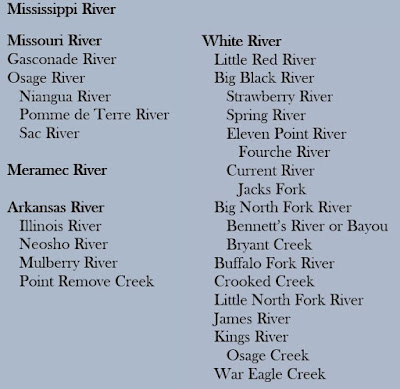
- The Blue line highlights Ozark tributaries. The list below is not all-inclusive.
Enjoy your Ozarks' History.
References:
Colton, Joseph Hutchins. Colton's Map of the Southern States. Including Maryland, Delaware, Virginia, Kentucky, Tennessee, Missouri, North Carolina, South Carolina, Georgia, Alabama, Mississippi, Arkansas, Louisiana, and Texas. Showing also part of adjoining states & territories locating the forts & military stations of the United States & showing all the railroads, railroad stations, & other internal improvements. New York, J. H. Colton, 1861. Map. https://www.loc.gov/item/99447011.


No comments:
Post a Comment