Thursday, January 30, 2020

Up from the Ashes

In the 1800s, courthouse fires notoriously destroyed valuable county records across the United States. These fiery disasters generally give the moniker of "Burned Counties." This is the case in Baxter County, Arkansas. Yet, circumstances are different for Baxter County today. We are grateful to Wayne & Carolyn Camp for their care and donation of six volumes of Baxter County Land Transcriptions Records from 1857 - 1899. Newly discovered records thought destroyed or lost will shed light on the history we assumed ascended in the flames of 1890. We are looking forward to seeing familiar and unknown names of our region's pioneers to come to light. This will be a great year.

Vincent S. Anderson with Wayne & Carolyn Camp. 1
The Story

   In 1880, the Baxter County Building Commissioners contracted to build a new courthouse on the square in Mountain Home. The new courthouse endured almost a decade, and the wooden structure burned in February of 1890. Many of the county's valuable records burned or became water- and smoke-damaged, and it was not feasible for the records to be maintained within the county's collection. Seven months later, the Baxter County Quorum Court levied a tax to construct a new courthouse.

   After the fire in 1890, County Clerk William F. Eatman immediately began the task of transcribing the damaged documents by hand. Eatman completed his task and his records were certified a little over a decade after the fire. Eatman served as Baxter County Circuit Clerk for 21 years, and he owned the Baxter County Abstracting Company of Mountain Home.

Wayne & Carolyn Camp Donation. 2


   The damaged Baxter County Land Transactions date back to 1857. The end result of Eatman's 10-year task produced a certified six-volume set of land records. Unfortunately, the land transcriptions were never placed back into Baxter County's possession.

New 1890 two-story brick, gothic-style Courthouse. 3
    Over the decades, Wayne and Carolyn Camp came into possession of these historical documents. In December of 2019, Wayne and Carolyn Camp donated the records to the Baxter County Library, and these records are currently in the Library's digitization project. It is estimated the project will take three months to complete. Once the records are digitized, the six volumes will be given to the Baxter County Clerk's Office and placed in the county vault. Then, the Baxter County Library will initiate the next phase of the project, which will be to transcribe the handwritten records.

Wayne & Carolyn Camp Donation. 4
Enjoy your Ozarks' History.

References. 
1. Baker, Chase. "Vincent S. Anderson with Wayne & Carolyn Camp." Baxter County Library. Accessed January 30, 2020.
2. Baker, Chase. "Wayne & Carolyn Camp Donation." Baxter County Library. Accessed January 30, 2020.
3. Government, Baxter County. Baxter County Government - History. Accessed January 30, 2020. http://www.baxtercounty.org/history.php. 
4. Baker, Chase. "Wayne & Carolyn Camp Donation." Baxter County Library. Accessed January 30, 2020.

Tuesday, January 14, 2020

Ozark Plateau 1861

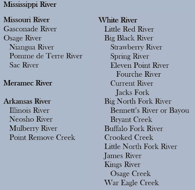
    Over the past few months, I have been looking for old maps with a focus on the Ozark Plateau to use in my research.  I decided to develop a few maps fitted for my liking & needs.  Below is an 1861 map from the Library of Congress.  The 1861 map below does not always show the Plateau in its perfection, and every boundary or tributary is not an exact replication or science.  Yet, this map includes many old roads, settlements, creeks, forks, and rivers. 
  • The Red line highlights the Ozark Plateau.  If the Plateau is in any part of a county, it is included on this map.
  • The Blue line highlights Ozark tributaries. The list below is not all-inclusive. 


My website will not let me post the actual size of the file because it is so large. Therefore, the map above is a thumbnail size of a large file. For those who want to use this map for future endeavors, be my guest. Please cite your source.

Enjoy your Ozarks' History.


References:
Colton, Joseph Hutchins. Colton's Map of the Southern States. Including Maryland, Delaware, Virginia, Kentucky, Tennessee, Missouri, North Carolina, South Carolina, Georgia, Alabama, Mississippi, Arkansas, Louisiana, and Texas. Showing also part of adjoining states & territories locating the forts & military stations of the United States & showing all the railroads, railroad stations, & other internal improvements. New York, J. H. Colton, 1861. Map. https://www.loc.gov/item/99447011.

Thursday, January 2, 2020

Ozarks' Slavery: Introduction


You must never write history...until you can hear the people speak. 1
 Arthur Boyd Hibbert
Medieval historian, Cambridge University 

   This is an axiom taught to me in a graduate seminar a few years ago, and it always works well for me. History's voice captivates me as I explore primary & secondary sources. After reading books, journals, forms, newspapers, and records, I begin to understand the perspective, or worldview, of my subject. When I wake up at night and hear the voices of the people I'm studying, I know I am beginning to understand my material.

   Historical voices are why I visit old estates, cemeteries, or familiar haunts and search for the obvious overlooked by myself and others. Sometimes, the obscure hides in the obvious. I believe abandoned roads & trails still hold familiar hints and a river's channel still possess a recognizable bend recorded on old maps. Even today, I can walk along stone fences that bear witness of a time when an Ozark barren (prairie) yielded to the will of our ancestors. 

   Lately, I am visiting old farms & gravesites of men and families who held political & social sway within the Ozarks. Today, I see their historical waysides eroding under our urge to develop new subdivisions; all the while, some old homesteads are wasting away among the red cedar & blackjack oak trees. As I look to see the toil and effort extracted under their influence, and I hear a familiar refrain from the Song of Solomon:

I have seen all the works that are done under the sun; 
and indeed, all is vanity and grasping for the wind.
Ecclesiastes 1:14

   Recently, I have undertaken a new project that may seem taboo to some of my readers. My focus is on Antebellum Slavery in the Ozarks, and there are caveats of this subject that are changing my perspective on slavery in the Ozarks. The scope of my study is not to badger every family that once held slaves. We are all in need of mercy and grace. My purpose is to discover the depth of the slavery institution within the Ozarks.

   I decided to embark on this subject in September 2019, and I took an opportunity to hear Dr. Brooks Blevins lectured on his latest Ozarks’ trilogy. In his book, History of the Ozarks, Volume 2: The Conflicted Ozarks, Blevins wrote two sentences that still cause me to pause and highlight a portion of his book. (Yes, I highlight books.) First, Blevins states:

History of the Ozarks, Volume 2: The Conflicted Ozarks     Even in circumstances free from the whip, slaves were subject to forced separation from family members, sexual abuse, and the ever present, oppressive psychological weight of subversive and deference. 2

   Secondly, the WPA (Works Progress Administration) in the 1930s under the Roosevelt Administration chronicled former slaves. From these narratives, Blevins observes:

     Forced separation from family members is the most common form of psychological abuse cited by former slaves interviewed in the 1930s.3

   One of the facets I am currently studying is children in Ozark slavery. In Kenneth F. Kipple's study "Slave Child Mortality: Some Nutritional Answers to a Perennial Puzzle," he reveals:

   Most slave children were exposed to many traumas, by the very nature of their enslavement. Poor diet, living conditions and lack of medical care led to a high rate of infant/child mortality...The death rate for white children at this time was approximately 12.9% whilst that for black children was double that at 26.3%.4

    Concerning the spread of slavery in the United States, I often refer to a map from the Library of Congress website:  Map Showing the Distribution of the Slave Population of the Southern States of the United States.5 Another asset is Lincoln Mullen's article from the Smithsonian Institution, “These Maps Reveal How Slavery Expanded Across the United States.” 6 Mullen's article also has some great animated maps worth the time to study.
Map Showing the Distribution of the Slave Population of the Southern States of the United States. 
Drawn by Hergesheimer and Leonhardt.
 Published by  Henry S. Graham 1861, Washington, D. C.
 Library of Congress.
    To assist in this endeavor, I also made modifications to the above 1860 Slave Population Map, and the Ozark Plateau is outlined in green. Just for fun, the Arkansas, Mississippi & Missouri Rivers are with a trace of blue.
1860 Slave Population Map of the Ozark Plateau outlined in Green.
   In October of this year, I downloaded the U. S. Census forms from Christian, Douglas, Howell, Ozark, Stone &Taney & counties in Missouri. I am also researching Carroll, Fulton, Izard, Marion & Searcy counties in Arkansas.  Currently, I am delving into the 1840, 1850 & 1860 Census records. I do not use Ancestry.com because the compiled data is often confusing and the statistics are sometimes inaccurate. Yes, pulling data straight from the Ancestry website will skew the data, and not everything on Ancstry.com is correct. 

   I am also obtaining data from the National Historical Geographic Information System (NHGIS). The NHGIS obtains digital data directly from the Census Bureau and provides easy access to summary tables and time series of population, housing, agriculture, and economic data, along with GIS-compatible boundary files, for years from 1790 through the present.7
 
My Current County Focus Group of the 1860 Slave Population Percentages.

   Though the percentages of slaves in the Ozarks look relatively small compared to the United States, they are figures I am endeavoring to comprehend today. Why?

When we look at the percentages for slavery per Ozark county,
we are not only talking about adults; 
we are also looking at a lot of children in slavery. 

  As I look through the data, tough questions begin to arise while looking for nuclear families within the Ozark slave population. After assembling population statistics, a couple of items are relevant: 
  1. The absence of potential African-American fathers in slave households is disproportionate to the number of potential African-American mothers. 
  2. For the amount of potential African-American mothers, many girls in slavery were becoming pregnant & bearing children by age 14-16.
   As the weeks of research begin to tabulate, I write down tough questions and concerns give way to voice.
Slave Mother & Children.8
  • How many Slaveholding families have Mulatto Slave children living with them without a potential or an eligible mother in the household? 
  • What are the age ranges of the children in slavery?     - This is surprising at times.
  • How many Slaveholding families have 1 Black Slave child living with them without potential or eligible mother in the household? What are the circumstances of this situation?
  • How many Slaveholding families with 2-5 Black Slave children living with them without potential or eligible mother in the household?
  • How many Slaveholding families have Mulatto Slave children living with them without a potential or an eligible mother in the household?
  • Which Ozark counties have the highest Mulatto population?
  • Which Ozark counties have more children in slavery than adults?
  • Who are the fathers of the Mulatto children when
    there is not a potential or eligible Mulatto male in the household or vicinity? Could it be the Slaveholder or one of their white family members?
  • If the evidence shows the lack of whole Slave Nuclear Families with no potential or eligible Father & Mother, do parents or family members live nearby?
  • Do slave children know their father, mother, siblings, or extended family?
  • Are all slaveholders Confederate soldiers or sympathizers? - The short answer is, "No." Actually, I have discovered some slaveholders in Ozark County, Missouri, listed as Union soldiers & officers. There's more on this in the future.
  • Do records or journals to show Union officers took advantage of inappropriate situations toward female and/or emancipated slaves? The short answer is, "Yes."
  • If so, what are the officer's names and the African-American girl's & ladies' names?
  • When looking at the 1860 U. S. Slave Census, what happens to these minors after Emancipation Proclamation on January 1st, 1863?
  • Where do slave families eventually go after the Emancipation & the Civil War?
  • What are the subsequent relationships between former slaves & prior slaveholders & households?
  • And...what are their names?
   If you have any other questions, post them at the bottom of this page.


   Though we may not know all the nameless faces held in slavery, I believe we can begin to hear their voices as we ask questions.

 Reflection:
   No matter our failures, flaws, or controversies, looking at our past can increase our ability to understand a portion of our historic Ozark culture. Whether we like it or not, slavery was a part of the Ozark tapestry. Understanding its texture, appearance, rigidity, disdain, and demise can enhance our ability to look at topics once only whispered.

   If you happen to be a person of faith and prayer, I would ask for you to pray that I would have wisdom and insight to delve into this subject. As we take this journey together, I hope you will pause & investigate our Ozarks' History.

My attempt to color a picture using software from https://www.colorizephoto.com/converter.
References:
  1. Boxall, Peter. The Cambridge Companion to British Fiction: 1980-2018, (Cambridge, United Kingdom: Cambridge University Press, 2019), 243.
  2. Blevins, Brooks. A History of the Ozarks, Volume 2: the Conflicted Ozarks, (Champaign, IL: University of Illinois Press, 2019), 18-19.
  3. Ibid.,19. 
  4. Kipple, K. F., and V. H. Kipple. “Slave Child Mortality: Some Nutritional Answers to a Perennial Puzzle.” Journal of Social History 10, no. 3 (January 1977): 290. https://doi.org/10.1353/jsh/10.3.284. 
  5. Hergesheimer, E. Map Showing the Distribution of the Slave Population of the Southern States of the United States. Compiled from the Census of 1860. (Washington, D. C.: Henry S. Graham, 1861) https://www.loc.gov/item/99447026/.
  6. Mullen, Lincoln. “These Maps Reveal How Slavery Expanded Across the United States.” Smithsonian.com, Smithsonian Institution, 15 May 2014, www.smithsonianmag.com/history/maps-reveal-slavery-expanded-across-united-states-180951452/
  7.  “IPUMS NHGIS.” National Historical Geographic Information System (NHGIS). Accessed January 1, 2020. https://www.nhgis.org.  
  8. “Children In Slavery: Take Your Child To Work Day Was Every Day.” Children In Slavery: Take Your Child To Work Day Was Every Day: Accessed January 2, 2020. https://slaveryfacts.org/classroom/children-in-slavery-take-your-child-to-work-day-was-every-day